
How many earthquakes have occurred? What was the most recent? Which were the deadliest? When will the next one strike? These are common questions in a country shaped by seismic activity. Let’s clarify the basics.
Earthquake or Tremor? Local Perceptions
While all ground movements are technically earthquakes (terremotos), Salvadorans differentiate them based on intensity and impact:
Earthquake (Terremoto): In the perception of the Salvadoran population, an earthquake is one that is strong enough to cause damage or casualties. Some earthquakes may not result in victims, but if they are strong enough, they can still be considered an earthquake.
Tremor (Temblor or sismo): In Spanish, or at least in El Salvador, the words “temblor” and “sismo” are used. In people’s minds, all “temblores” are “sismos”, but not all “sismos” are “temblores”. “Temblor” is practically used for “sismos” that are felt strongly and alarm the population.
On the other hand, “sismos” that are not “temblores” are those movements that are practically imperceptible but are recorded by machines that detect earthquakes at the national level.
Now that you know the difference between a tremor and an earthquake for Salvadorans, do you want to know where you can find data on the latest tremors? You can see them on this page from El Salvador’s Ministry of the Environment.
Earthquakes in El Salvador – Chronological list from most recent to oldest known
The oldest earthquakes occurred when El Salvador as a country did not yet exist. Remember that El Salvador is a relatively young nation, like the other countries that were part of the former Viceroyalty of New Spain, which existed until around 1821.
From that moment on, the territories that made up the viceroyalty decided their own destiny and became independent countries.
We bring you a table listing all the tremors that can be considered earthquakes in El Salvador. The table is sorted from the most recent earthquake to the oldest known or believed to have occurred.
| Date | Magnitude | Epicenter | Notes |
|---|---|---|---|
| January 5, 2025 | 6.3 | Off the coast of La Paz. 29.0 km southwest of Playa Costa del Sol. | Occurred around 11:18:48 AM. It had been a long time since such a strong earthquake was felt. Tremors continued throughout the day with smaller aftershocks. |
| May 30, 2019 | 6.8 (Richter scale) | Pacific Ocean, 66 km from Playa Mizata | Caused infrastructure damage. Los Chorros Highway was temporarily closed, and a tsunami warning was issued. |
| April 10, 2017 | 5.1 | Antiguo Cuscatlán, La Libertad | Part of a seismic swarm. A series of tremors caused panic among the population. |
| November 24, 2016 | 7.2 | South of Usulután, 163 km offshore | No casualties or significant infrastructure/housing damage. Felt nationwide. |
| October 14, 2014 | 7.3 | 65 km south of La Unión | Three deaths reported. Tremors were felt as far as parts of Nicaragua. |
| July 7, 2013 | 6.4 | La Libertad | Occurred off the coast of La Libertad. |
| August 27, 2012 | 7.4 | Between La Unión and San Miguel | Occurred at night (10:37 PM). |
| August 15, 2012 | 5.6 | La Libertad, 40 km south of Puerto de La Libertad (at sea) | Caused widespread alarm. No deaths; minor structural damage. |
| December 15, 2011 | 5.0 | San Juan del Gozo Peninsula, Usulután | No fatalities. 25 people injured in a church due to partial roof collapse. |
| January 18, 2010 | 6.0 | Ahuachapán | Felt in Guatemala and El Salvador. A 4.2 Richter aftershock struck 17 minutes later, alarming residents. |
| November 26, 2009 | 6.0 | Ahuachapán | Lasted 28 seconds. Panic led to evacuations. Damage reported in Santa Ana and Soyapango. |
| October 7, 2005 | 6.2 | Ahuachapán | Phone networks disrupted for several minutes. |
| November 20, 2004 | 6.3 | Acajutla, Sonsonate | Minor damage; no fatalities. |
| February 28, 2001 | 6.1 | Offshore Usulután | One injury reported. Likely an aftershock of the January 13, 2001 earthquake. |
| February 13, 2001 | 6.6 | San Pedro Nonualco, La Paz | Major destruction. Second earthquake that year, one month after the January 13 quake. 315 deaths. Damage concentrated in La Paz, San Vicente, and Cuscatlán. |
| January 13, 2001 | 8.0 | Offshore Usulután | Largest earthquake since 1986. Severe damage; ~944 deaths. Violent shaking caused widespread destruction of homes and buildings. Left a lasting trauma. |
| October 10, 1986 | 5.7 | Los Planes de Renderos, San Salvador | Devastating: ~1,500 deaths, 10,000 injured, 200,000 displaced. Deadliest in Salvadoran history. Rubén Darío building collapse killed 500. |
| June 19, 1982 | 7.3 | La Libertad coast | 9 deaths; ~100 injured. |
| May 3, 1965 | 6.5 | La Libertad coast | 110 deaths. |
| May 6, 1951 | 6.2 and 6.0 | Jucuapa, Chinameca | Two major quakes 4 minutes apart. 400 deaths. |
| December 26, 1937 | 5.9 | Ahuachapán | Significant damage in Atiquizaya and Ahuachapán. |
| December 19, 1936 | 6.1 | Near San Vicente Volcano | 200 deaths. |
| May 21, 1932 | 7.1 | Coastal region | 10 deaths. |
| April 28, 1919 | 5.9 | San Salvador Volcano | ~100 deaths. Volcanic origin. |
| June 7, 1917 | 6.7 and 6.5 | San Salvador Volcano | Volcanic tremors preceding the volcano’s eruption days later. ~1,050 deaths. |
| September 6, 1915 | 7.7 | El Salvador coast | ~5 deaths. |
| July 18, 1912 | 5.9 | Santa Ana | — |
| September 15, 1902 | 8.1 | Ahuachapán | 400 deaths. Triggered a tsunami affecting El Salvador and Guatemala. La Barra de Santiago hardest hit. |
| March 25, 1899 | 6.7 | San Vicente | 34 deaths; severe damage in San Vicente. |
| October 2, 1878 | 6.0 | Alegría, Usulután | 19 deaths. |
| March 19, 1873 | 7.3 | San Salvador | 57 deaths. |
| March 4, 1873 | 6.4 | Texacuangos | Notable damage in Ilopango, Soyapango, Ciudad Delgado, Santo Tomás, and Mejicanos. |
| December 8, 1859 | 7.3 | Comasagua | Severe devastation in Atiquizaya and Comasagua. |
| November 6, 1857 | 7.1 | South of Lake Ilopango | Significant damage in Cojutepeque. |
| April 16, 1854 | 6.6 | Southeast of Cerro San Jacinto | Complete destruction of San Salvador. |
| October 1, 1839 | 5.9 | San Salvador | San Salvador severely affected. Aftershocks continued for 15 days, forcing government offices to relocate to Cojutepeque. |
| March 22, 1839 | 6.2 | Between Nejapa and San Salvador | Damaged homes in Opico, Quezaltepeque, San Salvador, and Nejapa. |
| December 1838 (exact day unknown) | 7.3 | Chinameca, San Miguel | — |
| February 7, 1831 | 7.1 | San Salvador | San Salvador destroyed. |
| August 10, 1815 | 6.1 | San Salvador | — |
| 1806 | 6.4 | San Salvador | Capital city suffered destruction. |
| February 2, 1798 | 6.2 | Antiguo Cuscatlán | Major damage in San Salvador and Antiguo Cuscatlán. |
| September 21, 1787 | 5.7 | San Miguel Volcano | Caused by volcanic activity preceding the eruption of Chaparrastique Volcano. |
| November 29, 1783 | 7.6 | San Vicente | — |
| May 30, 1776 | 7.5 | San Salvador | — |
| May 13, 1748 | 6.4 | Central region | — |
| 1736 | 7.2 | Panchimalco | Destroyed homes in San Francisco Chinameca and Panchimalco. |
| 1730 | 6.5 | San Salvador | San Salvador destroyed. |
| March 6, 1719 | 7.0 | Between San Vicente and San Salvador departments | ~7 deaths. |
| 1707 | Unknown | San Salvador | Area of modern San Salvador left in ruins. |
| 1683 | Unknown | Ostúa, Santa Ana | — |
| 1671 | Unknown | San Salvador | — |
| November 3, 1658 | Unknown | North of San Salvador Volcano | — |
| September 30, 1656 | 6.0 | San Salvador Volcano | Caused by the volcano’s eruption. Lava covered Nejapa. |
| 1625 | Unknown | San Salvador | Major damage in San Salvador. |
| April 21, 1594 | Unknown | San Salvador | Significant damage; ~13 deaths. |
| May 23, 1575 | Unknown | Between Santo Tomás and San Marcos | ~3 deaths. |
Why do earthquakes occur in El Salvador?
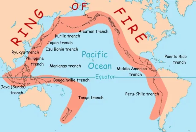
El Salvador sits atop the collision of three tectonic plates (Cocos, Caribbean, and North American), making it part of the seismically active Pacific Ring of Fire. Major destructive earthquakes tend to recur every 20–30 years, with the last catastrophic event in 2001.
While science cannot predict earthquakes, understanding terms, risks, and history helps Salvadorans navigate life in one of the world’s most tremor-prone regions.